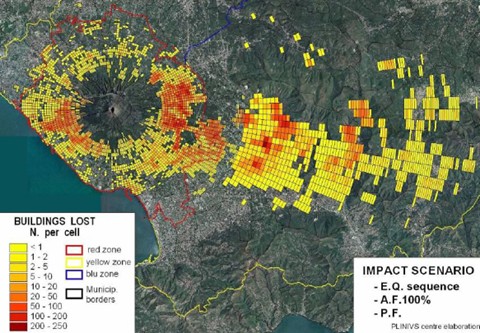
Because so few potential clients are directly threatened by volcanoes, the insurance industry hasn’t developed sophisticated models to estimate damage due to cataclysmic eruptions. But sooner or later, a volcano located near a major population center is going to blow, and government cash alone may not be enough to heal the economic wounds. Could the insurance industry fill the void while making a tidy little profit to boot? A pair of British researchers make the case, asserting that it’s entirely possible to guess how many lives and homes will be destroyed by an eruption. The impact of Mount Vesuvius on Naples provides their central object lesson:
In terms of human casualties, the impact depends on the extent of evacuation achieved, and a very effective evacuation is assumed in which 98.5% of the population have been evacuated by the end of Phase 1. However, given the immense population at risk there would still be an estimated 8,000 deaths and 13,000 injuries resulting from this large-scale eruption, and there are also certain to be insurance implications from these casualties.
The authors do note, however, one potential complicating factor in the nascent volcano-insurance field: whether to issue policies that can cover the climate-altering effects of major eruptions, too. Think that sounds far-fetched? Meet Mount Tambora, the Indonesian volcano responsible for the infamous “Year Without Summer.”


Jordan // Feb 17, 2010 at 3:33 pm
I remember listening to a Planet Money podcast where they had an economist on who explained that if insurance worked perfectly and covered every possible eventuality, we’d more or less have the perfect redistributive system. All the risk would be pooled, so money would be shifted around to help everyone who needed it. Admittedly that relies on some unrealistic assumptions, but it’s an interesting idea.
Brendan I. Koerner // Feb 17, 2010 at 4:48 pm
Yeah, I agree. Insurance is a pretty amazing innovation, and there is probably a “perfect” way to do it. But that would require not only 100 percent accurate modeling, but also completely uniform (and non-greedy) behavior by insurance companies. And that ain’t gonna happen.
Yangshao // Feb 17, 2010 at 11:21 pm
i’ll be working around these this summer:
http://www.diggles.com/pgs/2005/fig57Veniaminof.jpg
http://cimss.ssec.wisc.edu/sage/geology/lesson3/images/Figure%2012%20Aniakchak%20Caldera%20Alaska.jpg
when they went off 4000-3700 years ago, the fall out changed the face of north american history. the latter being the single largest volcanic eruption of the holocene…
Brendan I. Koerner // Feb 18, 2010 at 8:23 pm
@Yangshao: Um, wow. Curiosity piqued. How do you measure the strength of prehistoric volcanic eruptions? And what were the climactic effects? Any evidence the eruption might’ve affected the entire globe, a la Tambora? Would be so awesome if an Alaskan volcanic explosion somehow affected, say, the development of ancient Sumeria.
Yangshao // Feb 18, 2010 at 11:49 pm
well, it depends on the kind of volcano. this was an explosive eruption, and these may be measured by volume displaced. conservative estimates put it at ~70km3, but may have been much larger (like 150km3). this would make it larger than mazama (crater lake). we don’t know exactly…but ash was found all the way up into the arctic on both sides of the bering sea; and the distribution of sulfer gas, and acid rain, was more far-reaching than that. northern latitude eruptions tend to impact higher latitudes harder; equatorial eruptions impact the equator primarily. the mid-holocene eruptions of volcanoes on the ak peninsula had major cooling effects. some suggest this activity may have been responsible for the “neoglaciation” but that may be a stretch. i can send you a phd diss on all this if you’re interested.
Yangshao // Feb 18, 2010 at 11:56 pm
you’ll appreciate this…http://pubs.usgs.gov/dds/dds-40/album.html
the top 12-18 are within 150 miles of my house. the ones on top are relatively close. what’s wrong with this picture…